BATHYMETRIC AND HYDROGRAPHIC SURVEY SERVICES IN KENYA AND AFRICA
Bathymetric or Hydrographic Surveying is the survey of physical features present underwater and entails measuring the nature of sea, lake or river floor. 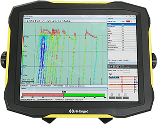 It is the science of measuring all factors beneath water that affect all the marine activities like dredging, marine constructions, offshore drilling among others.
At Orbital Africa Ltd, we offer professional and reliable Bathymetric and Hydrographic Survey services aimed at obtaining data about water depth, the shape of the sea floor and coastline, the location of possible obstructions, and other features of water bodies. This data is key in helping the marine transportation system of the country safe and functioning.
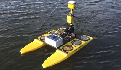
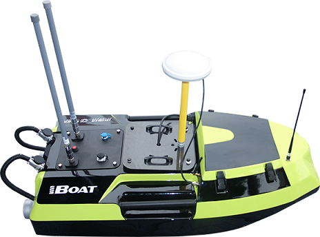
Having been in existence for so many years, our experience and expertise in the field of Bathymetric and Hydrographic Survey is unmatched. Our team of skilled surveyors is not only well-trained, but also uses latest equipment such as Multibeam Sonar or Side Scan Sonar Echo-sounders and Modern Global Navigation Satellite System (GNSS) to measure the depth and determine positions and terrain of the sea, lake or river floor.
It is the science of measuring all factors beneath water that affect all the marine activities like dredging, marine constructions, offshore drilling among others.
At Orbital Africa Ltd, we offer professional and reliable Bathymetric and Hydrographic Survey services aimed at obtaining data about water depth, the shape of the sea floor and coastline, the location of possible obstructions, and other features of water bodies. This data is key in helping the marine transportation system of the country safe and functioning.
Having been in existence for so many years, our experience and expertise in the field of Bathymetric and Hydrographic Survey is unmatched. Our team of skilled surveyors is not only well-trained, but also uses latest equipment such as Multibeam Sonar or Side Scan Sonar Echo-sounders and Modern Global Navigation Satellite System (GNSS) to measure the depth and determine positions and terrain of the sea, lake or river floor.
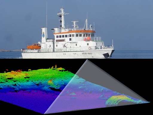
Bathymetric and hydrographic surveys allow us to measure the depth of a water body as well as map the underwater features of a water body. Multiple methods can be used for bathymetric surveys including Multi-beam and Single-beam Surveys, ADCPs, sub-bottom profilers, and the Ecomapper Autonomous Underwater Vehicle. We use bathymetric surveys for many different types of research including flood inundation, contour of streams and reservoirs, leakage, scour and stabilization, water-quality studies, dam removal, biological and spill, and storage and fill in reservoirs as well as ponds etc. Our Bathymetric and Hydrographic Survey service comes up with data that helps mariners to guide large ships in and out of ports, as well as boost Disaster Response by looking for changes in depth or debris from storms below the surface of the water that could endanger sea vessels. Bathymetry is performed to map the under-water bottom with a high level of accuracy. It will help correlation and interpretation of the data obtained from other methods, which yield sub-bottom information and allow a quality check of the results. Since other methods measure thickness from the bottom, this accuracy is essential.
The principle of the method is to send an acoustic signal and measure the travel time to derive a depth. This depth conversion process is done by first measuring the velocity of sound in the water at different depths. This calibration is done twice a day to ensure a good accuracy. The water depth measurements can be expected to be accurate to within ± 10 cm.The bathymetry equipment is a small equipment which is mounted on a boat and survey conducted along with other geo-physical methods. Survey is conducted in a grid pattern. The line spacing is decided based on the resolution required. The accurate positioning is achieved using a Differential Global Positioning System. View sample Bathymetric Survey photos here >>> 1 2 3
Bathymetric and hydrographic Survey Methods
- Multi-beam Surveying: A multibeam echosounder attached to a boat sends out a wide array of beams across a "swath" of the waterbody floor. As the beams are bounced back from the waterbody floor, the data is collected and processed. The processed data can be viewed in real time on the boat during the survey. Multi-beam surveying is generally done in larger water bodies.
- Single-beam Surveying: Rather than sending out a wide set of beams, the single-beam bathymetry measures the water depth directly under the boat. Single-beam surveys are generally used for smaller water bodies.
- Acoustic Doppler Current Profiler (ADCP): ADCPs are used throughout USGS to measure streamflow. ADCPs measure water velocity by transmitting the sound waves which are reflected off sediment and other materials in the water. Data collected from the ADCPs can then be used to for bathymetric mapping.
- Sub-bottom Profilers: Sub-bottom profilers are most commonly used to view the layers of sediment and rocks under the water body floor. A transducer sends a sound wave to the water body floor. This sound wave can penetrate the water body floor. The data returned from the sound waves can be mapped to show the layers beneath the water body floor.
- Ecomapper Autonomous Underwater Vehicle: The Ecomapper can collect detailed bathymetric data, down to one-foot (1ft) contours, in places that are difficult to reach with boats. The Ecomapper uses side-scan sonar and a Doppler velocity log.
Bathymetric and Hydrographic Surveys Domains and Use
- Flood inundation;
- Establishing the Contour of rivers, streams and reservoirs;
- Water-quality studies;
- Removal of Silt from Dams;
- Hydro-power projects;
- Biological and oil-spill;
- Storage and fill in reservoirs and ponds.
Procedure for Bathymetric and hydrographic Survey
Bathymetric and hydrographic survey entails measurement and description of features which affect maritime navigation, marine construction, dredging, oil exploration/drilling, pipeline damage assessment and related disciplines. Strong emphasis is placed on water depth soundings, shorelines, tides, currents, sea floor and submerged obstructions that relate to the previously mentioned activities. The surveys uses the raw data collected through the hydrographic survey process into information usable by the end user.
Before the advent of electronic surveying equipment including electronic distance meters, GNSS and echosounders (water depth recorders), shallow water depths were measured with sounding poles or lengths of ropes. The approximate locations of the soundings were then drawn on maps to the best ability of the surveyor. As one can imagine, this method was not nearly as accurate as it could be. Echosounders made determination of water depths a lot more accurate; however, the horizontal accuracy of the soundings was still based on the judgment of the individual surveyor. Adding electronic distance measuring techniques to the process meant that the horizontal and vertical positions of the soundings could be determined more accurately with minimal judgment calls on the part of the Surveyor.
Bathymetric and Hydrographic Survey Applications
- Dock and Harbour Engineering;
- Irrigation and land reclamation;
- River works and Land reclamation;
- Hydro-Power projects studies;
- Removal of Silt from Dams, Reservoirs etc;
- Mapping of Flooding and Control.
Procedure for Bathymetric and Hydrographic Survey
- The depth of the ocean, lake or river bed can be determined;
- The shore lines can be determined;
- Hydrographic Mapping for Navigation Charts Preparation;
- Location of sewer fall by measuring the direct currents;
- Identifying and locating of the mean sea level;
- Scouring, silting and irregularities of the river bed etc can be identified;
- Tide measurement and determination.
- River and stream discharge measurement;
- Planning for engineering works for huge structures e.g. bridges, dams etc.
You can also request a quotation for Bathymetric and Hydrographic Survey services by sending us an e-mail at: [email protected] or by calling us on: +254-719-672296.