BC101 - Introduction to Geographical Information Systems
Introduction
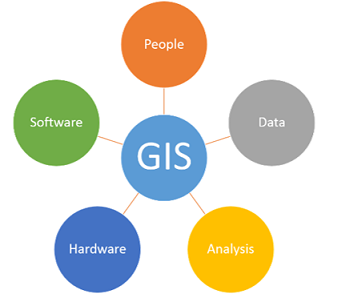
Geographic Information System (GIS) is one of the most remarkable innovations of all time, which has become an essential tool in resource management and planning. It is an information system comprising hardware, software, methods, data and people, all working together to capture, store, manage and manipulate, analyze, and display spatial information, to solve complex problems and enable decision making. It uses the concept of location of entities, whereby nearly everything can be assigned a geographic location. It uses other basic concepts such as space, distance and direction.
Course Overview
This course will introduce you to the basics of GIS, with a focus of equipping you with fundamental skills of working with spatial data. It will introduce you to the nature, types and sources of spatial data and the use of various GIS Software to manage, analyze and visualize this data. The course includes both practical software training and explanations of the concepts you need to know to make informed decisions as you start your journey to becoming a GIS analyst.
Course Objectives
- Understand what GIS is and what it can be used for i.e its applications;
- Get Started with various GIS Software in the market;
- Know how to create and manage your own GIS data;
- Understand the basics of Geospatial data creation and management.
Course Contents
- Introduction to GIS concepts: Definitions of core geospatial terminology and concepts; Objectives, components and applications of GIS; The history of GIS - how it is used today, and the future of GIS; Introduction to GIS Software – QGIS and ArcGIS Basics etc.
- Spatial Reference Systems: Coordinate and Spatial Reference Systems; Datums and Ellipsoids; Map Projections; Coordinate Transformations.
- Nature of GIS Data: Data types and models; Data Characteristics & metadata; Feature representation in GIS; GIS data sources; Data Capture; A shapefile and Feature class; Data Editing; Geo-referencing; Digitizing in GIS; Spatial and Attribute Data.
- Geospatial Data Management: GIS Data File Formats; The Geodatabases: Features and Design; File Geodatabases, Personal Geodatabases; Introduction to GIS database (Microsoft SQL), functions and applications; Maintaining spatial and attribute data integrity using subtypes; Performing GIS data validation; Updating and managing the GIS databases.
- Geospatial Analysis: Introduction to raster data Analysis; Extraction, Digital Elevation Models, Classification, etc.; Introduction to vector data Analysis; Buffering, Clipping, etc.
Expected Learning Outcomes
On completion of this course, the participants are expected to:- Have an understanding of what GIS is (Can you explain it to a fifth grader?);
- Have a basic understanding on the operation of ArcGIS and QGIS;
- Be able to collect data from the field in real time, or from the internet and other sources;
- Be able to import data into GIS software and perform basic analysis.
Training Materials (Hardware and Software)
- A Laptop or PC;
- ArcGIS Desktop;
- Quantum (Q-GIS).
Course Training Details
- Registration: Please register here: Register
- Training Intake: Feb, May, Aug and Nov every year.
- Location: Nairobi, KENYA {NB: The course can also be offered in any city within Africa}
- Duration: 5 Days
- Mode: Onsite or online
- Training Fee: Kshs. 29,000 or USD 350 {NB: Up to 20% discount for: (i) University/College students) (ii) A group of 5 or more participants}
Training Style and Approach
- Onsite instructor-led training;
- Online training (optional);
- Use of PowerPoint Slides;
- Practicals/Fieldwork Exercises;
- Use of Case Studies on GIS Data Creation.
Who Should Attend?
The training targets professionals from the following industries and sectors:- GIS/Geospatial Students;
- Urban/Spatial Planning Professionals;
- Regional Planning Officers;
- UN Bodies e.g., UNHABITAT, UNDP etc;
- Ministry of Urban Development;
- Urban Transport Sector;
- Academic Institutions;
- Professionals from Health Sector;
- ...and many more!