CC315 - GIS for Crime Mapping and Analysis Course
Introduction
 Crime analysis is a law enforcement function that involves systematic analysis for identifying and analyzing patterns and trends in crime and disorder. Information on patterns can help law enforcement agencies deploy resources in a more effective manner, and assist detectives in identifying and apprehending the suspects. The training is meant to synthesize current concepts mostly of Geographical Information systems and mapping and technological advancements in the field of crime analysis. This training is meant to utilize the current concepts of GIS, mapping and technological advancements in the field of crime mapping and analysis as well as presentation of results using maps, info-graphs and statistical tables.
Course Overview
GIS is a useful and powerful analytical tool for mapping and analyzing crime hotspots in a given or specific locality. This course also introduces Geographic Information Systems (GIS) to law enforcement agencies and officers; security professionals, as well as those who carry out criminal investigations. As a practical course, the focus is to impart and enhance law enforcers with practical and analytical skills using GIS analysis tools such as g Geocoding and Geospatial intelligence for presentation, communication and decision making which forms the bedrock of ensuring prevention of crimes and provision of requisite security to citizens. The participants will have a basic understanding of the emerging field of Geospatial Intelligence as well as acquire basic knowledge of adopting GIS technology in provision of security services to ordinary citizens. This course is also ideal for DCI, NIS and military expatriates.
Course Objectives
Geospatial tools offer the capability of monitoring, predicting and countering threats, while helping to strategize and support field operations. The use of big data, advanced geospatial analytics software and sophisticated imaging technologies from (very) high-resolution remote sensing satellites, UAVs and other sensors enables seamless flow of information between intelligence and law enforcements agencies in pre, real-time and post-combat operations.This course will enable the participants to:
- Provide law enforcement professionals with an understanding of GIS concepts, principles & how they can be applied in provision of security to citizenry.
- Undertake field data collection and analysis for crime mapping and analysis with GIS as well as data management and synthesis.
- Utilize GIS, remote sensing and Geospatial intelligence tools to identify and map crime hotspots, crime trends, patterns and problems within the internal security sector in GIS context.
- Perform various GIS mapping, analysis workflows and modelling to aid decision making in prevention & mitigation of criminal activities in urban context.
- Learn GIS both as platform for creating spatial databases, analysis, modelling tool; and for disseminating crime information to all the stakeholders.
Learning Environment
The learning and teaching strategies will follow student centered mode. Through the lectures, in-depth reading and group discussions, the participants will acquire advanced knowledge about application of Geo-technology in crime mapping and analysis. The students will develop skills to use Geospatial techniques for data acquisition, processing and analyses of ground based data as well as Geospatial intelligence data. In this training, we shall employ an 80-20 approach i.e. 80% of the time for practicals whilst 20% for theory.
Course Contents
- Introduction to GIS and Mapping: An overview of the Five (5) GIS components (Software, Hardware, Data, People and Procedures); The GIS interface.
- Introduction to Crime Mapping: GIS data (Raster & vector data); Shapefiles (point, polyline & polygon); Using GPS/smartphone to map crime locations.
- GIS Data and Geocoding: GIS data & metadata types; GIS catalog & toolbox; data management; georeferencing raster data; Geocoding processes (Latitude/Longitude to street addresses conversions and reverse geocoding).
- Advanced Spatial Analysis Techniques: Geospatial analysis (intersect, clip, aggregate, dissolve, union, spatial join, relate, buffer and spatial query etc).
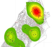
- Crime Mapping and Hotspot Analysis: Introduction to crime mapping using GIS; crime GIS data types; crime point data; developing crime GIS database; analyzing crime data in GIS point data; crime hotspot analysis; creating GIS heatmaps and a web mapping application.
- Crime Geospatial Intelligence: Introduction to Thiessien and Voronoi polygons; The GIS DEMs, DTMs and DSMs; analyzing crime using location intelligence algorithms; GIS buffering of crime zones; using Google maps APIs in crime location mapping; creating a crime reporting GIS dashboard.
- Crime Information Dissemination Methods: Displaying crime data using GIS hotspots maps; GIS infographs; statistical tables and charts; GIS web maps and operation dashboard; Google maps applications.
- Case Study - Nairobi City Crime Mapping: Mapping crime in Kayole Estate in Nairobi; creating crime maps; creating GIS web applications and report.
Expected Learning Outcomes
On completion of this course, the participants are expected to:- Obtain solid skills and experience is application of geo-information and earth observation tools/techniques in crime mapping, analysis and reporting.
- Acquire Geo-skills needed for collection, interpretation & management of spatial information, using mobile GIS apps/GPS to support crime mapping.
- Gain in-depth skills using Geospatial tools that help in development of crime hotspot maps, urban GIS crime databases, zoning crime prone areas and for crime prevention policy formulation and implementation.
- Acquire hands-on skills and expertise in the use various crime mapping and analysis platforms such as EpiCollect5, GIS software, GIS/Google web mapping; GIS dashboards for reporting crimes amongst other platforms.
- Get acquainted with relevant GIS and other Geospatial techniques to provide project specific solutions in the field of crime investigations and reporting.
Training Materials (Hardware and Software)
- A Laptop or PC;
- Satellite/drone images;
- EpiCollect5 App;
- ArcGIS Online;
- GIS Operation Dashboard;
- ArcGIS & Q-GIS;
Course Training Details
- Registration: Please register at: Register
- Training Intake: Feb, May, Aug and Nov every year.
- Location: Nairobi, KENYA
- Duration: 10 Days
- Training Fee: Kshs. 80,000 or USD 850 {NB: Up to 30% discount for: University/College students}
Training Style and Approach
- On-site instructor-led training;
- On-line training (optional);
- Use of PowerPoint Slides;
- Practicals/Fieldwork Exercises;
- Use of Case Studies on Crime Mapping.
Who Should Attend?
The training targets professionals from the following industries and sectors:- Law Enforcers e.g. DCI;
- National Intelligence Service;
- Police Officers;
- Military Personnel;
- Public & Private Security Agencies;