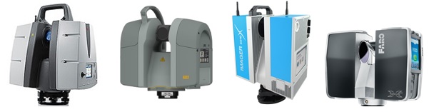
A 3D TERRESTRIAL LASER SCANNER
3D Terrestrial Laser Scanners are used for detailed 3-dimensional data acquisition of objects. This is a very fast and cheap way to produce 3D Models. Terrestrial Laser Scanners have applications in many different areas such as deformation measurements, quality control or cultural heritage monitoring. 3D Terrestrial Laser Scanners provide detailed and highly accurate 3D data rapidly and efficiently. Applications are wide ranging, including Topography, Mining, As-Built Surveying, Architecture, Archaeology, Monitoring, Civil Engineering and City Modelling. 3D Terrestrial Laser Scanners are rugged and fully portable instruments, tested under strict conditions for a reliable performance even under highly demanding environmental conditions.
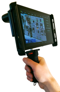
If you have already worked with a terrestrial laser scanner, you may have encountered different challenges. You always have some areas that cannot be captured with a terrestrial laser scanner (such as Leica, Trimble, Stonex or Topocon scanner) in consequence of size or limited accessibility of the object to be scanned or for lack of time. There are two options for scanning these missing areas: The first option is to scan the areas from additional positions. But you often need many positions - this circumstance causes much more work and cannot be realized technically everytime. The second option is to capture the areas by means of a handheld 3D scanner, such as DPI-8 from DotProduct LLC, and merge both scanner datasets together in a software (e.g. FARO Scene) afterwards.
You can also request a quote for 3D Terrestrial Laser Scanning Services by sending us an e-mail at: [email protected] or call us on: +254-719-672296.