AspMap Training in Madagascar
A 10-Day Training on the GIS AspMap based on .NET was conducted in Antananarivo, Madagascar to 20 Staff Members from The Centre for Geoinformatics Application in Rural Development (CGARD). The training was a success!
More Details... Photos VIEW PROJECT
GIS, GPS and RS Resource Mapping
World Vision Kenya, through Orbital conducted GIS Mapping of resources in semi-arid parts of Kenya. The aim of the project was to analysing the livelihood status,levels and gaps in Isiolo and Samburu counties.
More Details... Photos VIEW PROJECT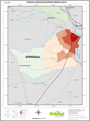
Kitengela Town Growth Analysis
The project entailed data collection using GPS; data capture (buildings, roads, PoIs) from satellite imagery for 2000, 2005, 2010 and 2015. We also developed a model of analysing Kitengela growth in 2050.
More Details... Photos VIEW PROJECT
GIS Mapping and Analysis of Safcom Masts in Kenya
On Feb 2017, Safaricom Kenya contracted Orbital Africa to carry out the GIS mapping and analysis of all the telecommunication masts in Kenya. The Project was completed on 5th June 2017.
More Details... Photos VIEW PROJECT
Development of a GIS Web-Based LIS for Buruburu Estate
Orbital was contracted by the Nairobi County to develop a GIS-based Land Information System for Buruburu Estate in 2016. The GIS technologies employed were ArcGIS Server, JS, Postgres/PostGIS.
More Details... Photos VIEW PROJECT
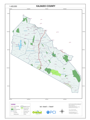
Cadastral Survey of an 100-Acre Block in Kajiado County
Orbital Africa was contracted by Imara Washirika Self-Help Group to prepare a sub-division plan and carry out subdivision and titling of an 100-acre block of land into 69 parcels.
More Details... Photos VIEW PROJECT